-
Tours
-
-
- Domestic Tours
-
-
- Resorts
- Car Rentals
- Destinations
- Getaways
- Hotels
- Tools
- * Workation
- * Tour Plans
- Blog
- List Property
- * Offers *


![]() Hill Station
Hill Station
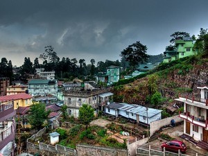
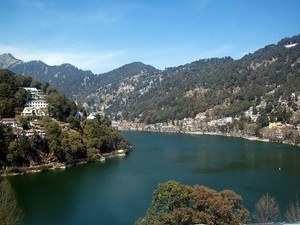
At a distance of 98 km from Guwahati, 377 km from Dhaka, 414 km from Kohima, 420 km from Cooch Behar, 572 km from Siliguri, 594 km from Darjeeling, 631 km from Gangtok and 1116 km from Kolkata, Shillong is a mesmerizing hill station in East Khasi Hills district of Meghalaya in India. Shillong is the capital city of Meghalaya as well as the headquarters of East Khasi Hills district. It is one of the most picturesque hill stations in India and among the must include places in your honeymoon tour packages.
Perched at an attitude of 1496 m, Shillong is situated on a plateau bounded by the Umiam gorge on the north, Diengiei Hills on the northwest, and the hills of the Assam valley on the northeast. Shillong Peak is the highest point in Shillong with an altitude of 6449 feet. The city gets its name from the deity Shyllong or Lei Shyllong, who is worshipped at the Shillong Peak. The British fondly called Shillong the 'Scotland of the East' as the rolling hills around the town reminded the European settlers of Scotland.
Earlier a small village, Shillong became the new civil station of the Khasi and Jaintia hills in 1864 CE. In 1874, it became the capital of composite Assam under British rule due to its favorable location between the Brahmaputra and Surma valleys. Shillong remained the capital of Assam till 1969 when the autonomous state of Meghalaya was formed. In 1972 CE, Meghalaya turn out to be a full-fledged state ...

![]() Hill Station
Hill Station
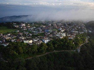
At a distance of 54 km from Shillong, 80 km from Mawsynram, 84 km from Dawki, 146 km from Guwahati, 292 km from Tezpur, Cherrapunji or Cherrapunjee is a small sub divisional town in the East Khasi Hills district of Meghalaya. It is one of the wettest places on the earth and among the must visit places in Meghalaya as part of honeymoon tour packages.
The original name for this town was Sohra, which was pronounced 'Churra' by the British. This name eventually evolved into the current name, Cherrapunji, which means the 'land of oranges'. According to the history, Cherrapunji is the traditional capital of a Nongkhlaw hima, an independent Khasi state. Between 16th and 18th centuries, the local residents were ruled by their tribal Syiems (chiefs) of Khyriem in the Khasi Hills. Tirot Sing was the last important Syiem of this area, who later admitted to the British in 1883 and ruled this place till independence.
Receiving an annual rainfall of about 11,777 mm, Cherrapunji happens to be the second wettest place on the planet after Mawsynram. The town receives both south-west and north-east monsoons. Despite receiving an abundant rainfall, Cherrapunji faces an acute water shortage and the inhabitants have to trek very long distances to obtain potable water. The excessive rain causes soil erosion which has deprived the land of Cherrapunji and the surrounding valleys.
Located in Meghalaya, Cherrapunji is a paradise ...

![]() Hill Station
Hill Station
At a distance of 60 km from Shillong, 63 km from Nongkrem, 81 km from Cherrapunjee, 104 km from Mawlynnong, 107 km from Dawki, and 152 km from Guwahati, Mawsynram is a scenic village located in East Khasi Hills district of Meghalaya. It is the wettest place on the earth and among the best places to visit in Meghalaya.
Situated at an altitude of 1400 m, Mawsynram is the rain lover's paradise as it receives the highest rainfalls in India. With 11,872 mm of rainfall received annually, Mawsynram beats Cherrapunji by a slender margin. Cherrapunji receives 11,777 mm of rainfall. The rains are so intense in Mawsynram that the villagers use thick grass to sound-proof their homes from the thunderous rain. The 'Maw' in Mawsynram is a Khasi word meaning 'stone'. It symbolizes the unique megaliths unearthed in the Khasi Hill area.
Apart from rains, Mawsynram is also known for lush green vegetation, floating clouds, roaring waterfalls and the colourful orchids. Mawjymbuin Cave, Mawlyngbna Village and Jakrem are the top places to visit in Mawsynram. Also, the Mawsynram tourism is known for the secretly placed caves and the adventure sports activities.
Guwahati Airport is the nearest major airport which is about 163 km from Mawsynram and is well-connected by flights with cities like Kolkata, Mumbai, Delhi, Hyderabad, Bangalore, Chennai and Jaipur. About 153 km, Guwahati Railway Station is the nearest rail head to Mawsynram which has direct trains from Kolkata, Delhi, Agartala, ...

![]() Hill Station
Hill Station
At a distance of 9 km from Riwai, 78 km from Shillong, 81 km from Cherrapunjee, 91 km from Jowai, 92 km from Mairang, 124 km from Nongpoh, 170 km from Guwahati, 203 km from Kamrup, 211 km from Morigaon, 263 km from Barpeta, Mawlynnong is a scenic village located in the East Khasi Hills district of Meghalaya in North East India. Also referred as 'God's own Garden', it is renowned as the cleanest village in Asia and among the top places to visit in Meghalaya.
Blessed with pristine natural beauty, Mawlynnong is a community based eco-tourism initiative by Meghalaya Tourism Department. This 100 years old village won the title of Asia's cleanest village in 2003 and the cleanest village in India in 2005 which was given by the travel magazine 'Discover India'. There were about 95 homes in Mawlynnong and the people residing here belong to the Khasi and Garo tribe. The village community has made collective effort to maintain the ambience of a clean village. The waste is collected in the dustbins made of bamboo, directed to a pit and then used as manure.
The village is quite pretty, especially in the monsoons when there is lush greenery all around, with waterfalls and abundance of flowering orchids add to the beauty of the village. Living Root Bridge at Riwai, Sky Walk / Sky View, Balancing Rock, Church of Epiphany and Rymben Falls are the prime places to visit in Mawlynnong. The village also offers breathtaking view of Bangladesh plains as it is located on the Indo-Bangla ...

![]() Hill Station |
Hill Station | ![]() Nature & Scenic
Nature & Scenic
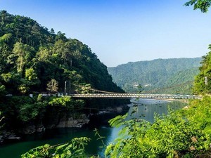
At a distance of 30 km from Mawlynnong, 57 km from Jowai, 71 km from Nongkrem, 80 km from Shillong, 84 km from Cherrapunjee, 95 km from Mairang, 172 km from Guwahati, 205 km from Kamrup, 223 km from Morigaon, 265 km from Barpeta, Dawki or Dauki is a small town in West Jaintia Hills district of Meghalaya. Situated on the banks of Umngot River, it is one of the beautiful places to visit in Meghalaya.
Sandwiched between India and Bangladesh, Dawki is a border town in Jaintia Hills. It is also a major center of trade between India and Bangladesh. Dawki-Tamabil is one of the few road border crossings between India and Bangladesh which is mainly used for coal transportation to Bangladesh and also other places of India. The crystal clear Umngot River of Dawki is a major attraction that marks the natural separation between the Khasi and Jaintia Hills.
Besides being a trade hub, this small town is known for its immense natural beauty. Umngot River, Umngot Bridge, Jaflong Zero Point and Burhill Falls are the major places to visit in Dawki. Dawki is an ideal spot for camping and adventure water sports like snorkeling, kayaking and boating in Umngot River. Visitors can also take part in other adventure sports such as rappelling and zip-line here. The town attracts large number of tourists especially in the month of March-April as it hosts the annual boat race on the Umngot River.
Guwahati Airport is the nearest airport which is about 190 km from Dawki and has well connected ...

![]() Hill Station
Hill Station
At a distance of 57 km from Dawki, 64 km from Shillong, 89 km from Mawlynnong, 100 km from Mairang, 101 km from Cherrapunji, 114 km from Mawsynram, 125 from Silchar and 156 km from Guwahati, Jowai is a town and the headquarters of West Jaintia Hills district in Meghalaya, India. Renowned for its scenic setting and breathtaking views, Jowai is one of the popular tourist destinations in North East India and among the top places to experience Meghalaya Tourism.
Situated at an altitude of 1380 m, Jowai is bounded by the Myntdu River on three sides and Bangladesh bordering it on the southern fringes. Jowai is the home land of Pnar tribe. The people share common heritage with the Khasi people like the customs, family tradition and religion. Jowai is also an important business and education hub of the entire district catering to students from all over the district as well as the adjacent parts of Assam and Bangladesh.
Jowai was the political and commercial Centre of Jaintia Hills since the British rule in India. Legend says that, the Jaintia Hills did not belong to the territory of the Khasi Hills and also were not under the Khasi kings. They had their own administration under the Jaintia kings who resided in a town called Jaintiapur in Surma valley. In 1835, the British captured Jaintia hills and collected regular taxes like land tax and property tax. Later, the property tax was changed into house tax in 1860 and also the British introduced the income tax and taxes on ...
Similar Getaways